

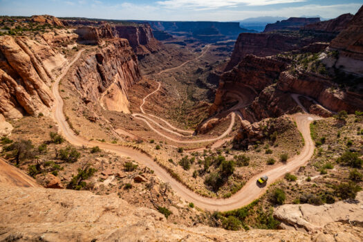
Look down from the Island in the Sky district of Canyonlands National Park and you’ll see a narrow dirt road carved into the cliffs below. It twists back and forth through a series of switchbacks that seem almost impossible from above before disappearing into the enormous canyon country surrounding the Colorado River.
This is Shafer Trail, and today it is one of the most recognizable four wheel drive roads in the Moab area.
But Shafer Trail wasn’t built for recreation.
Long before Jeep Wranglers started descending its switchbacks, people used this natural passage through the cliffs to travel between the mesa above and the canyon country below. Over time, the route became a livestock trail, then a uranium hauling road, and eventually one of the signature backcountry drives in Canyonlands National Park.
Driving Shafer Trail today isn’t simply a great Moab Jeep adventure. You’re following a route through more than a century of modern Moab history and a much longer history of human travel through canyon country.
Before There Was a Road
The geography of Island in the Sky makes travel challenging.
The mesa rises dramatically above the surrounding landscape, with sheer sandstone cliffs separating the top of Island in the Sky from the Colorado River and White Rim country thousands of feet below.
Finding a practical route through those cliffs was incredibly valuable.
According to the National Park Service, Native Americans used routes through this area long before European American settlement, traveling between the mesa and the resources found in the canyon country below.
What eventually became Shafer Trail follows one of these natural weaknesses through the cliffs.
Then ranching arrived.
John “Sog” Shafer and the Ranching Era
The trail gets its modern name from the Shafer family, Mormon pioneer settlers who ran livestock in the Island in the Sky country.
Beginning around 1916, John “Sog” Shafer used and improved the trail to move livestock between seasonal grazing areas. Cattle could graze on the mesa during warmer months and be moved into the lower White Rim country during winter.
Imagine that trip without a Jeep.
There were no guardrails.
No graded switchbacks.
No GPS.
No National Park Service road crews.
Moving livestock through this country meant negotiating an extremely narrow route along cliffs where a mistake could be fatal. Historical accounts describe livestock slipping from trails in this rugged terrain.
Shafer improved the route and made access into the canyon easier, but it remained a working stock trail rather than anything resembling today’s recreational road.
For decades, ranchers throughout what is now Canyonlands National Park constructed and improved trails like Shafer and Murphy to move cattle and sheep between grazing areas. Ranching continued across much of Canyonlands from the late 1800s well into the twentieth century.
Then something happened that completely changed Moab.
Uranium Changes Everything
In the 1950s, southeastern Utah became one of the centers of America’s uranium boom.
The federal government wanted uranium for the country’s rapidly expanding nuclear program, and the Atomic Energy Commission encouraged prospectors to search the Colorado Plateau.
Suddenly, remote desert country that had primarily been known to ranchers, cowboys and a handful of explorers became valuable mining territory.
There was one major problem.
There weren’t enough roads.
The Atomic Energy Commission helped change that.
Nearly 1,000 miles of roads were constructed or improved across southeastern Utah as prospectors searched for uranium. Many of the dirt roads we now think of as classic Moab four wheel drive routes have connections to this era.
Shafer Trail was one of them.
The old ranching route was widened and improved so trucks could travel through Shafer Canyon carrying equipment and uranium bearing rock between the backcountry and Moab.
Think about that the next time you’re carefully navigating one of the Shafer switchbacks.
Large trucks once traveled this road hauling ore.
The uranium boom dramatically changed Moab as money, workers, prospectors and equipment poured into southeastern Utah. It also changed access to the surrounding landscape.
Places that previously required horses, livestock trails or days of difficult travel suddenly had roads.
Ironically, those mining roads helped create something very different from the industry they were designed to support.
They helped introduce people to the beauty of Canyonlands.
Uranium Roads Helped Create Canyonlands National Park
As roads pushed farther into canyon country, more people could finally experience this extraordinary landscape.
The uranium boom didn’t ultimately produce huge quantities of uranium within what is now Canyonlands National Park, but the roads constructed during the search made the region much more accessible.
People began coming simply to see it.
Arches National Monument superintendent Bates Wilson became one of the strongest advocates for protecting the Canyonlands region. He took government officials into the backcountry by Jeep, showing them the canyons, mesas, rivers and landscapes that he believed deserved national park status.
Those early Jeep trips helped people understand what maps and photographs couldn’t fully communicate.
In 1964, Canyonlands National Park was established.
Shafer Trail had gone from an Indigenous travel route to a ranching trail, then to a mining road.
Its next chapter was recreation.
Shafer Trail Today
Today, Shafer Trail is one of the signature backcountry experiences in Canyonlands National Park.
From near the Island in the Sky Visitor Center, the road drops approximately 1,500 vertical feet through the sandstone cliffs. The National Park Service describes the Shafer section as roughly 5.2 miles before reaching the junction with White Rim Road and Potash Road.
The switchbacks are the part everyone remembers.
From above, the road looks like someone drew a zigzag line directly down the canyon wall.
From behind the steering wheel, it’s an entirely different experience.
You slowly descend through layers of sandstone as the landscape changes around you. What looked impossibly far below from the mesa gradually becomes the landscape surrounding you.
And then the canyon opens.
Shafer Trail to Potash Road: One of Moab’s Great Drives
One of our favorite ways to experience Shafer Trail is to make it part of a larger loop.
Start by driving from Moab toward Island in the Sky in Canyonlands National Park. Spend some time exploring the overlooks before heading toward Shafer Trail.
Then descend the switchbacks.
At the bottom, instead of continuing onto the White Rim Road, take the route toward Potash Road and Moab.
This creates an incredible transition from high desert mesa to deep canyon country.
The unpaved road eventually follows the Colorado River beneath enormous sandstone walls before connecting with the paved portion of Highway 279 and returning to Moab.
It’s hard to find another drive that packs this much scenery, geology and history into a single Moab adventure.
Can You Drive Shafer Trail in a Rental Jeep?
Shafer Trail is exactly the type of road where having the right vehicle matters.
The National Park Service highly recommends a high clearance four wheel drive vehicle with low range gearing for Shafer Trail. Conditions can change quickly because of rain, snow, erosion and road maintenance.
That’s one reason a Jeep Wrangler Rubicon from Canyonlands Jeep Adventures is such a great option for visitors wanting to experience Shafer Trail.
Our Jeeps are specifically set up for exploring Moab’s backcountry, allowing you to spend your day at your own pace rather than following a tour schedule.
Stop for photographs.
Spend extra time at an overlook.
Explore Island in the Sky.
Descend Shafer Trail.
Follow Potash Road along the Colorado River.
Then return to downtown Moab after one incredible day.
A Few Things to Know Before Driving Shafer Trail
Shafer isn’t technically difficult under good conditions compared with many of Moab’s more challenging four wheel drive trails, but drivers shouldn’t underestimate it.
The road is narrow and exposed, and there are sections where vehicles need to use pullouts to pass.
The National Park Service notes that uphill traffic has the right of way and asks drivers to use available berms and pullouts when allowing vehicles to pass. The speed limit is 15 mph.
Weather matters too.
Rain and snow can dramatically change backcountry road conditions. Always check current Canyonlands National Park road conditions before leaving Moab.
And remember that Shafer Trail and the White Rim Road aren’t the same thing.
A day use permit is not currently required for Shafer Trail Road or Potash Road, but continuing onto the White Rim Road does require a day use permit.
More Than Just a Jeep Trail
It’s easy to look at Shafer Trail and see an incredible dirt road.
But knowing its history changes the experience.
When you drive down those switchbacks, you’re traveling through different chapters of southeastern Utah history.
Native peoples traveled through this landscape long before today’s road existed.
Ranchers pushed livestock through the canyon when there was little more than a rough trail.
John “Sog” Shafer helped improve the route beginning in the early twentieth century.
Uranium prospectors and truck drivers transformed it during the uranium boom of the 1950s.
Those mining roads opened previously inaccessible country to visitors.
And eventually, people realized that perhaps the greatest value of Canyonlands wasn’t what could be removed from the ground.
It was the landscape itself.
Drive a Piece of Moab History
There are plenty of places around Moab where you can take a beautiful photograph.
Shafer Trail gives you something more.
It gives you a story.
It’s the story of Native travel, ranching, uranium mining, the transformation of Moab and eventually the creation of Canyonlands National Park.
More than a century after John “Sog” Shafer moved livestock through this canyon, visitors from around the world are still following his route.
They’re just doing it in Jeeps now.
If you’re visiting Moab and want to experience Shafer Trail for yourself, Canyonlands Jeep Adventures can help you plan a self guided adventure with a Jeep Wrangler Rubicon built for Moab’s backcountry.
Come see Canyonlands from the pavement.
Then discover the Moab that begins where the pavement ends.